Leica Geosystems, part of Hexagon, today introduced the Leica TerrainMapper-2, the latest solution in the company’s hybrid sensor road map that integrates LiDAR and image capture technology in airborne sensors and allows users to collect more data per flight.
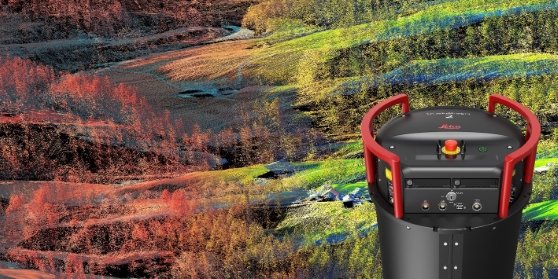 Leica TerrainMapper-2 integrates LiDAR and imaging for regional mapping projects and offers simple upgrade path to oblique imaging system.
Developed to execute complex and challenging regional mapping projects, the TerrainMapper-2 incorporates new imaging technology and reduces system complexity for higher efficiency. The upgrade of the TerrainMapper-2 to an integrated system controller and storage makes it easy to install in any survey aircraft by eliminating the additional equipment rack. The system also offers a seamless upgrade path to the Leica CityMapper-2, the markets only oblique imaging and LiDAR hybrid sensor.
TerrainMapper-2 is a high-performance linear-mode LiDAR system with two integrated Leica MFC150 nadir cameras (RGB & NIR) featuring Leica Geosystems’ unique mechanical forward motion compensation (FMC) that allows image capture in low-light conditions. Allowing users to fly longer during each day, this sensor enables the capture of high-quality orthophotos during LiDAR flight missions with fewer impacts on flight schedules.
“The addition of a high-performance camera system to the TerrainMapper allows us to offer higher-resolution image products on our LiDAR projects,” said Woolpert, Inc. senior vice president and geospatial sector lead Joe Seppi. Woolpert is a long-time user of Leica Geosystems airborne sensors. “More importantly, it does this without requiring additional flight lines not needed for the base LiDAR product, saving us valuable time. The TerrainMapper-2 also allows us an easy upgrade path to the full oblique CityMapper-2 as our business continues to grow.”
One sensor for modularity and seamless upgrade paths
As part of the RealTerrain solution, the TerrainMapper-2 combines with the unified multi-sensor post-processing workflow, HxMap, to process even the largest data sets at the highest speeds. Customers increase efficiency and productivity with advanced filters and precise point cloud alignment algorithms. Using edge computing, the LiDAR data undergoes discrete return extraction from the full waveform data on the fly, allowing faster ground processing results. In addition, both discrete return and waveform data can be stored, allowing full flexibility for the end-user.
“The development of the TerrainMapper-2 was the next logical step in our hybrid road map for airborne sensors,” said Leica Geosystems product manager Ron Roth. “With the recent release of the CityMapper-2 for urban areas, our customers also needed these same advanced imaging capabilities for regional LiDAR projects. With the TerrainMapper-2, we will now be able to support their needs for increased flexibility, scalability, accuracy and higher productivity.”
Source www.leica-geosystems.com


.jpg)


")